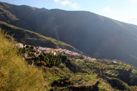
The village is located 800 meters above sea level and has 501 inhabitants (2013). To the municipality belong the towns of Rubite, Los Galvez and Rambla del Agua inside, and El Lance and Los Casarones on the Mediterranean coast. The Contraviesa is a mountain range that runs parallel to the coast line and the Sierra Nevada. His peaks have an average height of 1100 -1200 meters.
In the fourteenth century, the administration of the Nasrid monarchs had set up a special character to the farmhouses of the Alpujarras mountains, configuring it in a territorial organization based on entities called Tahas. In one of them, "Taha of Suhayl" or "Small Cejel" was a farmhouse, named Rubite, which with the passage of time and history, suffer all the vicissitudes and changes by which to this day has passed the old "Kingdom of Granada".

Points of Interest in Rubite
- Church: Iglesia de la Inmaculada Concepción (17th century);
- Aljibes Rurales Almohades;
- Viewpoint "Mirador del Aljibe"
- Old mill: El Antiguo Molino de Harina;
- The beaches (see below).

Festivities in Rubite
- Fiestas de la Rambla del Agua en honor a la Virgen de las Angustias is celebrated in June;
- In August Fiestas de Casarones is celebrated and also the Fiestas of the patron of Rubite in honor a la Virgen del Rosario;
- In August there is Almendra Rock; a rock concert with several regional rock groups;
- On the 7th of October the Fiestas in honor de la Virgen del Rosario are celebrated;
- In November the festival of the chestnuts is celebrated.

The Beaches of Rubite
Photo Gallery of Rubite
Basic Information Rubite
Rubite (36°48′32″N 3°20′53″O)
Altitude: 800 meters
Population: 501 (2013)
Distances:
Distance to Granada: 82 km
Distance to the beach: 16 km
Distance to Airport Malaga: 140 km
Distance to Airport Granada: 97 km
Touristic level: low - medium - high
Authentic level: low - medium - high
Facilities:
- Supermarkets: no
- Banks: no
- Restaurants: no
- Bars: yes


